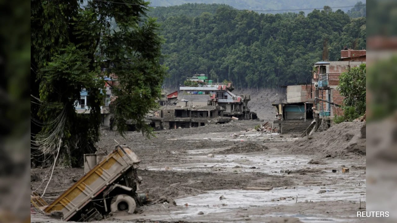
High-altitude hydrology in the Hindu Kush Himalaya is dictated by a fragile equilibrium between cryospheric melt and moraine containment structures. When rising ambient temperatures accelerate the volumetric expansion of supraglacial water bodies faster than natural drainage channels can accommodate, the mechanical integrity of surrounding terminal moraines reaches a critical threshold. The resulting cataclysm—commonly categorized as a Glacial Lake Outburst Flood (GLOF)—discharges millions of cubic meters of water and debris within hours, transforming localized alpine anomalies into transboundary hydraulic shockwaves. Standard disaster reporting frequently reduces these complex geophysical cascades to superficial weather narratives, ignoring the structural variables that govern hydraulic failure.
The Three Pillars of Cryospheric Destabilization
Unpacking recurrent disasters along transboundary river corridors requires examining the physical drivers that convert stable ice reserves into high-velocity debris flows. Three distinct variables dictate the magnitude of any outburst event.
- Thermal Forcing and Meltwater Accumulation: Sustained positive degree-days at high altitudes accelerate surface ablation. Meltwater pools within supraglacial depressions, compounding rapidly as thermal energy transfers directly to the ice-debris matrix.
- Geomorphic Containment Integrity: Terminal and lateral moraines act as natural dams. Composed of unconsolidated boulders, gravel, and ice cores, these structures lack structural engineering standards. As hydrostatic pressure increases against the inner wall, internal piping and seepage compromise internal friction angles.
- Cascading Mass Displacements: Outbursts are rarely isolated point failures. The sudden drainage of an upper supraglacial lake often unleashes a high-energy kinetic wave that strikes secondary downstream lakes or colluvial deposits, triggering secondary dam breaches and exponentially multiplying peak discharge volumes.
The Hydraulic Cost Function of Transboundary Basins
To understand the downstream devastation inflicted upon river valleys such as the Bhotekoshi and Trishuli basins, one must analyze the mathematical relationship governing flood wave propagation and energy dissipation. Peak discharge ($Q_p$) in a GLOF is a function of breach formation time, initial lake volume, and hydraulic head:
$$Q_p = k \cdot V^{m} \cdot h^{n}$$
Where $V$ represents the drained volume, $h$ denotes the breach depth, and $k, m, n$ are empirical coefficients determined by channel roughness and sediment concentration. When a glacial lake in the Tibet Autonomous Region breaches and drains within a single operational cycle, the sudden influx of water into narrow, steep Himalayan gorges prevents standard flood attenuation.
The cost function escalates non-linearly due to sediment entrainment. As the leading edge of the flood wave mobilizes riverbed alluvium and colluvial slope material, the fluid transforms into a hyper-concentrated debris flow. Density increases from standard water ($\approx 1,000 \text{ kg/m}^3$) to debris-laden flows exceeding $2,000 \text{ kg/m}^3$. This transformation magnifies the impact pressure exerted on civil infrastructure by an identical factor, neutralizing the design safety margins of run-of-the-river hydroelectric plants, reinforced bridges, and highway embankments.
Operational Blind Spots in Regional Early Warning Systems
Mitigating high-altitude cryospheric hazards requires real-time telemetry across geopolitical boundaries. Yet, structural limitations continue to impede disaster risk reduction frameworks.
Upper catchment zones where supraglacial lakes originate are frequently situated in remote, high-altitude terrain lacking continuous in-situ meteorological instrumentation. Consequently, disaster management authorities rely heavily on post-formation satellite imagery analysis, such as Normalized Difference Water Index (NDWI) shifts, which identify expansion phases only after critical volumetric thresholds have been crossed.
Furthermore, transboundary data-sharing protocols remain fragmented. Because hydrometeorological precursors materialize in sovereign upstream territories before manifesting as catastrophic downstream impacts in nations like Nepal, information asymmetries delay emergency reaction times. Standard precipitation forecasts are entirely ineffective for GLOF prediction, as these events occur independently of local rainfall—driven instead by internal lake dynamics, thermal ice-clastic calving, or subsurface drainage tunnel collapses.
Strategic Engineering Priorities for High-Risk Watersheds
Addressing recurrent alpine flood vectors requires moving away from reactive emergency response toward direct structural intervention and automated telemetry.
Siphon Drainage and Controlled Lowering
Engineering teams must prioritize active mitigation on high-risk glacial lakes identified via remote sensing inventories. Deploying high-capacity siphon systems or cutting controlled drainage channels through stable bedrock reduces total lake volume and lowers the hydrostatic head, permanently eliminating the risk of catastrophic overtopping.
Sediment-Resilient Infrastructure Design
Run-of-the-river hydroelectric facilities and cross-border trade hubs located within high-hazard corridors must transition from traditional civil design codes to dynamic vulnerability models. Engineering blueprints should incorporate subterranean sediment bypass tunnels, high-strength debris deflection walls, and automated acoustic monitoring arrays linked directly to automated floodgate actuation systems.
Institutionalizing Bilateral Hydrological Telemetry
Establishing real-time sensor networks across upper Tibetan sub-basins connected via direct, automated satellite downlinks to downstream emergency operations centers will remove political and logistical bottlenecks. Early warning must be triggered by hydrostatic pressure spikes and seismic shock signatures of initial dam ruptures rather than visual confirmation.
Deploy automated sensor arrays with satellite telemetry at all inventoried high-risk supraglacial lakes across upper transboundary basins to secure real-time hydrostatic data before volumetric thresholds reach critical failure points.