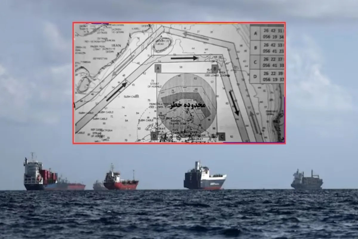
The headlines are screaming about a "new map" issued by Iran regarding the Strait of Hormuz. They want you to believe that Tehran is suddenly playing the role of a concerned maritime traffic cop, warning vessels about "mine-infested waters." The mainstream media is eating it up, framing this as a spike in regional tension or a genuine warning of an impending naval blockade.
They are wrong. They are falling for a masterclass in asymmetric psychological warfare that has nothing to do with actually dropping iron in the water and everything to do with manipulating global insurance premiums and naval deployment costs.
If you think this is about "safety," you’ve already lost the plot.
The Geography of Fear vs. The Reality of Logistics
The Strait of Hormuz is roughly 21 miles wide at its narrowest point. Approximately one-fifth of the world’s total oil consumption passes through this choke point. The "lazy consensus" suggests that Iran’s goal is to physically block the strait. This is a fundamental misunderstanding of Iranian naval doctrine.
Iran doesn't need to block the strait. They only need to make the idea of the strait being blocked credible enough to trigger a global economic seizure.
A sea mine is a cheap, low-tech weapon. A Soviet-era contact mine costs less than a high-end laptop but can disable a $2 billion destroyer. When Iran releases a "map" of mines, they aren't providing a service. They are establishing "Legalized Ambiguity." By defining where the mines might be, they force every commercial shipping entity to rethink their risk assessment.
I have watched maritime logistics firms burn through millions in "war risk" surcharges the moment a PDF map like this hits the wire. You aren't seeing a military maneuver; you’re seeing a tactical strike on the global supply chain's nervous system.
The Myth of the Minefield
Let’s dismantle the technical premise. Real mine-laying is a high-risk, high-visibility operation. If Iran were truly carpeting the strait with bottom-dwelling or moored mines, the U.S. Navy’s 5th Fleet—specifically their MH-53E Sea Dragon helicopters and Avenger-class mine countermeasures ships—would track every single deployment in real-time.
A map is a confession of weakness, not a display of strength.
- The Bluff: By releasing a map, Iran signals "we have mines here."
- The Reality: If they actually intended to destroy shipping, they would keep the locations secret.
- The Goal: Forced rerouting. By "warning" ships away from certain sectors, Iran effectively bottlenecks traffic into narrower lanes that are easier to monitor and harass with fast-attack craft (FAC).
This is a digital blockade. It costs Iran zero fuel and zero hardware. It costs the rest of the world billions in lost time and increased insurance "deadweight" costs.
Why the U.S. Navy is Playing the Wrong Game
The traditional response to these maps is to increase patrols. This is exactly what the IRGC (Islamic Revolutionary Guard Corps) wants. Every time a carrier strike group enters the Persian Gulf to "ensure freedom of navigation," it creates a target-rich environment for the very asymmetric tactics Iran excels at.
The U.S. spends hundreds of thousands of dollars per hour to operate a single ship in these waters. Iran spends the price of a social media manager to tweet a map that makes that ship's mission ten times more complicated.
We are fighting a 21st-century psychological war with 20th-century metal-and-diesel logic.
The Insurance Trap
Most people don't realize that the "owners" of the Strait of Hormuz aren't the navies; they are the underwriters at Lloyd’s of London. When Iran issues a "mine warning," they are talking directly to the insurance brokers.
- Risk Rating: The moment a "new map" is published, the Joint War Committee (JWC) reviews the area.
- Premium Spike: Ship owners are hit with an Additional Premium (AP) for entering a "listed area."
- The Pass-Through: These costs are passed to the consumer.
Iran has realized that they can tax the global West without firing a single shot. The map is the invoice.
Challenging the "Imminent Conflict" Narrative
Is there a chance of a "kinetic" event? Always. But the "danger" isn't the mines. The danger is the maritime industry's over-reliance on centralized routing.
If you ask a shipping captain, "Should we follow the Iranian map?" they will say yes, out of an abundance of caution. That caution is the weapon. It creates a predictable path for every vessel, making them easier targets for electronic warfare (GPS jamming) or "limpet mine" attacks, which are far more surgical and deniable than a field of floating explosives.
We saw this in 2019 with the attacks on the Kokuka Courageous and the Front Altair. Those weren't sea mines from a map. Those were magnetic mines placed by divers or small boats. The "map" is the distraction; the small-team infiltration is the reality.
The Actionable Truth for Global Markets
Stop treating these geopolitical theater pieces as "news." They are market signals.
If you are an investor or a policy analyst, you should ignore the "where" of the map and look at the "when." Iran releases these coordinates precisely when they need leverage in diplomatic negotiations or when domestic pressures require a show of "strength" against the Great Satan.
Technical Specifications of the Threat
To understand why the map is a farce, look at the physics of the Strait:
- Average Depth: 50 meters.
- Currents: Strong, tidal-driven currents.
- The Physics Problem: Moored mines in these currents often "dip" under the surface or break their chains. A precise "map" of mines in the Strait of Hormuz is an oxymoron. Any map they give you is a lie because the sea doesn't allow mines to stay in one place with that kind of GPS accuracy.
If the map says a mine is at $26° 34' N, 55° 00' E$, it’s either a lie or the mine will be five miles away by Tuesday.
The Zero-Sum Game of Naval Posturing
The West’s obsession with "freedom of navigation" operations (FONOPs) is a trap. We are validating Iran’s claim that they control the strait by reacting so violently to their every whim.
Imagine a scenario where we simply stopped reporting on these maps. If the maritime industry ignored the psychological static and relied on internal sensor data rather than Iranian press releases, the leverage would vanish overnight. But we can’t. Our system is built on "transparency," which Iran has brilliantly hacked to spread "translucent" threats.
The Final Disruption
The next time you see a headline about an Iranian naval map, don't look at the coordinates. Look at the price of Brent Crude. Look at the stock price of maritime insurance conglomerates.
Iran isn't trying to sink ships; they are trying to sink the predictability of the Western trade model. They are using our own risk-aversion against us. The mine isn't in the water. The mine is in the minds of the people reading the map.
We aren't witnessing a military escalation. We are witnessing a cost-of-business hike enforced by a country that knows it can't win a carrier-on-carrier fight, so it wins the spreadsheet fight instead.
Turn off the map. Look at the math. The "minefield" is a ghost.


