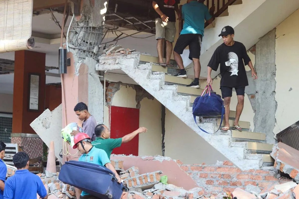
The 7.7-magnitude earthquake that struck off the coast of eastern Indonesia's Flores Island on August 15, 2026, offers a brutal case study in tectonic vulnerability, structural physics, and logistical failure points. Recording a shallow focal depth of approximately 10 to 15 kilometers, the event generated severe ground acceleration, localized building collapses, and cascading secondary hazards, including landslides and a brief tsunami alert. With a confirmed death toll of 38, thousands of displaced residents, and compromised arterial transit corridors, the event exposes the exact operational and engineering variables that dictate survival outcomes in high-activity seismic zones.
Evaluating this crisis requires moving past generalized disaster reporting. By analyzing the physical mechanics of the shock, the performance failure of regional infrastructure, and the logistical friction of the emergency response, stakeholders can isolate the precise drivers of loss.
The Mechanics of Shallow Crustal Shaking
The destructiveness of an earthquake correlates directly with focal depth, energy release characteristics, and local site amplification. The Flores event occurred at a shallow depth offshore, positioning the energy release zone close to the surface boundary.
Energy Attenuation and Depth
Shallow hypocenters restrict the volume of Earth through which seismic waves travel before reaching surface structures. As energy waves propagate upward from a 10-kilometer depth, geometric attenuation is minimized. The ground surface experiences higher peak ground acceleration compared to deep-focus events of identical magnitude.
Frequency Content and Structural Resonance
The recorded ground motion featured high-frequency shear waves capable of exciting low-rise masonry buildings and non-engineered residential structures common to rural Flores. When the dominant frequency of seismic waves matches the natural frequency of a building, resonance occurs. This amplification factor turns structural frames into dynamic force multipliers, leading to sudden progressive collapse.
Secondary Tectonic Manifestations
The rupture mechanism triggered over 50 aftershocks ranging between magnitudes 3.6 and 6.2, maintaining continuous stress on already fractured building materials. Concurrently, the vertical displacement of the seafloor generated sub-meter tsunami waves, prompting a three-hour regional warning before oceanographic data confirmed stability and allowed cancellation.
Infrastructure Vulnerability and Spatial Isolation
The spatial distribution of casualties and property damage highlights a critical mismatch between regional structural stock and seismic load requirements.
The Residential Collapse Vector
The majority of fatalities occurred during the early morning hours while occupants were inside residential dwellings. Non-ductile masonry, unreinforced brick walls, and heavy timber-and-tile roofs lack tensile strength. Under lateral seismic loads, these materials shatter rather than deform plastically. The absence of ring beams and vertical tie-columns prevents load redistribution, ensuring that wall failure results in immediate roof collapse.
Arterial Grid Fragmentation
Logistical response depends entirely on road network integrity. The primary transport corridor on the island, the Trans-Flores highway spanning approximately 700 kilometers, suffered immediate blockages due to seismically induced landslides in the Ende regency.
- Topographical Vulnerability: Steep road cuts through weathered volcanic soils prone to shear failure during heavy ground shaking.
- Network Isolation: The severance of arterial links traps isolated regencies, such as Nagekeo, cutting off ground ambulance transit and heavy search-and-rescue asset deployment.
Communication Blackouts and Information Latency
Power grids failed across multiple cities and villages immediately following the tremor. Electrical substations and distribution lines dropped offline, disabling cellular repeater towers dependent on local grid power or lacking redundant battery backups. This electrical failure created an information vacuum, delaying accurate damage assessment reports to the National Disaster Management Agency (BNPB) and prolonging resource allocation cycles.
Operational Constraints in Disaster Response
Emergency management operations faced compounding friction variables during the initial seventy-two-hour window following the tremor.
Triage Under Structural Compromise
Medical infrastructure within the impact zone experienced direct operational disruption. Hospitals in Ende and surrounding districts had to evacuate patients and medical equipment to outdoor setup areas due to structural cracking and safety concerns. This forced emergency triage to take place in improvised tents, reducing acute surgical capacity precisely when trauma admissions peaked.
Evacuation Dynamics and Population Displacement
Approximately 2,000 residents self-evacuated to higher ground and temporary shelters in response to both the shaking and the initial tsunami alert. While spontaneous evacuation mitigates tsunami exposure, uncoordinated mass movement places severe strain on rural water, sanitation, and temporary housing infrastructure.
Resource Allocation and Engineering Mitigation
Mitigating future loss events of this magnitude requires shifting from reactive disaster relief to proactive structural hardening and network redundancy.
- Retrofitting Non-Engineered Stock: Introducing low-cost horizontal and vertical confinement elements, such as ferro-cement bands or reinforced concrete tie-columns, to existing rural masonry houses to prevent brittle collapse.
- Redundant Power Grids for Communications: Equipping critical disaster command centers and cellular towers with solar-array microgrids and independent battery storage to prevent post-earthquake information blackouts.
- Geotechnical Stabilization: Implementing slope stabilization, rock-netting, and drainage improvements along high-risk stretches of the Trans-Flores highway to maintain transportation continuity during seismic events.