Nature doesn't care about your weekend plans. While most of us were looking forward to a quiet Sunday, Severe Tropical Cyclone Vaianu has other ideas. This isn't just another rainy afternoon. Forecasters are sounding the alarm because this system is carrying "life-threatening" winds straight toward the North Island.
If you've lived in New Zealand long enough, you know the drill, but complacency is a killer. MetService and NIWA are tracking this Category 3 beast as it churns south from Fiji. It's packing sustained winds of 140km/h with gusts even higher. When meteorologists start using words like "damaging" and "life-threatening" in the same sentence, it's time to stop scrolling and start prepping.
The Reality of a Category 3 Strike
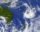
We're currently looking at a system that's rapidly gaining momentum. As of Wednesday, April 8, Vaianu is positioned roughly 2,000 km north of Wellington, but it’s moving fast. The "cone of uncertainty" is narrowing, and the bullseye is looking increasingly like the upper and eastern North Island.
Why is this one different? It's the timing and the ground conditions. Many regions are still dealing with saturated soil from previous rain events. When the ground is a sponge, it doesn't take much wind to topple a massive pine tree or a power pole. You don't need a direct hit to lose your roof or your power for a week.
The Prime Minister, Christopher Luxon, hasn't minced words either. He’s put agencies on "full notice." That’s government-speak for brace yourselves.
What the Winds Will Actually Do
High-sided vehicles and motorcycles are going to be death traps on the road this Sunday. If you're planning a road trip through the Kaimai Range or along the Desert Road, don't. Wind gusts at 150km/h can flip a caravan like a toy.
In suburban areas, your biggest enemy isn't just the wind—it's your neighbor's flying trampoline. Unsecured outdoor furniture becomes a missile at these speeds. It’s not just about your property; it’s about the safety of everyone on your street.
MetService expects to upgrade the current "Strong Wind Watches" to Orange or even Red Warnings by Friday. A Red Warning isn't a suggestion; it’s a signal that significant disruption and danger to life are imminent.
Why the East Coast is on High Alert
While the whole North Island is under a watch, the east coast is looking particularly vulnerable. Storm surges and hazardous coastal conditions are a massive concern. We’re talking about significant wave heights—some models suggest up to 8.5 meters.
If you live in a low-lying coastal area, you shouldn't wait for an official evacuation order if the water starts creeping up. Trust your gut. Coastal inundation happens fast, and by the time the alerts hit your phone, the roads might already be impassable.
Don't Wait Until Saturday
The biggest mistake people make is hitting the supermarket on Saturday night. By then, the bread is gone, the batteries are sold out, and the stress levels are through the roof. You've got a window of opportunity right now to get ahead of the chaos.
- Secure the yard. Flip that trampoline upside down. Tie down the BBQ. If it isn't bolted to the concrete, it's a potential projectile.
- Clear the drains. If your gutters are full of leaves, you’re asking for a flooded ceiling. Five minutes on a ladder today saves thousands in insurance claims later.
- Check your "Grab Bag." Essential meds, torches, batteries, and enough food for three days. Don't forget the manual can opener—your fancy electric one is useless when the grid goes down.
- Fill the tanks. Get your car fueled up today. If the power goes out, the pumps don't work.
The Far North is already setting up 'Manaaki Recovery Hubs'. This tells you that local councils aren't taking any chances. They’re preparing for isolated communities and road closures before the first raindrop even falls.
The Eye of the Storm Myth
If the wind suddenly drops on Sunday, don't go outside to check the damage. That’s likely the eye of the storm. The most dangerous winds often come immediately after the calm, hitting from the opposite direction and catching people off guard. Stay inside until the "all clear" is officially given by Civil Defence.
Stay off the phone lines unless it's a genuine emergency. Keep a battery-powered radio tuned to local stations. Information is your best defense when the Wi-Fi cuts out.
Look, we might get lucky. The track could shift further east into the Pacific. But betting your safety on "maybe" is a losing game. Get your house in order now. If the storm misses, you’ve just had a productive weekend of yard work. If it hits, you’ve given yourself and your family a fighting chance.
Monitor the MetService updates religiously over the next 48 hours. Secure your property, check on your elderly neighbors, and stay inside when the gale starts to howl. Sunday is going to be a long day.